The Wel River
Kayaking Route – difficult and strenuous
Introduction
The Wel River is the left tributary
of the Drwęca River. It flows through three provinces: Olsztyn, Ciechanów and Toruń. Its source starts in the village of Bartek and it is situated next to Dąbrowa Wielka Lake(in the Province of Olsztyn).In the area of Welski Landscape Park the Wel River flows around the village of Szczupliny in the Province of Ciechanów, then it flows around Rybno and to the south through several beautiful lakes.
Around the area of Cibórz the river meanders and changes its direction heading north-west; it continues its m
eandering through the town of Lidzbark flowing under nine bridges. It flows out of Lidzbark Lake through the areas of Kurojady and Chełsty where it changes into a typical mountainous stream and continues into the Province of Toruń.The river then flows
to the border of Welski Landscape Park where it splits into two channels. One of them is called Bałwanka; it flows into Tylickie(Fabryczne) Lake. Around the area of Bratian the river ends and flows into the Drwęca River; at which there is a greater flow of water.In several of the mountainous parts there are fish of great attraction trout, carp and other salmon-like fish. Warning: if you want to fish here you must pay an additional fee for mountainous rivers.
Some Statistics
Length of the River: 118 km, from the sources in the area of Wzgórza Dylewskie
Length of the kayak
ing Route: 98.5 km from Dąbrowa Wielka Lake to DrwęcaMedium Drop: 0.91 pro mille, several parts have a drop of 4.1 pro mille
Degree of spread: 4.2
Catchment area: 810.1 kilometer squared
Length of the area in Welski Landscape Park: around 80 km
The River flows through 10 lakes, 7 communes and 3 provinces
Travelling
From the direction of Działdowo via Lidzbark to Brodnica get out at Lidzbark
Miasto Station
From the d
irection of Działdowo to Iława get out at Tuczki StationFrom the direction of Brodnica to Iława get out at Bratian Station
From Zuromin to Olsztyn get out in Lidzbark, Koszelewski, Tuczki, Rybno,
Szczupliny, Wądzyn or Dąbrówno
From Działdowo to Ostróda get out at Kalbornia or Dąbrówno
From Działdowo to Iława get out at Kalbornia, Dąbrówno or Rybno
Lodgings
Lake)
Rybno (Center for Resting Foundation Poland-Belgium, next to Rumian Lake)
Rybno Recreation-Sport Complex (beach next to Zarybinek Lake)
Lidzbark (Town beach next to Lidzbark Lake)
Lidzbark-Ekoświt tel. (0-23) 69 61 182
Practical Advice
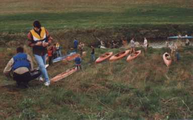
The whole kayaking route on the Wel River can be divided into three parts:
From 53 km (Podcibórz) to 45.2 km (Lidzbark) it is about a three to four hour trip.
From 44 km (Lidzbark) to 38.5 km (Kurojady) it is about one and a half hour trip.
III. The very difficult part: from 38.5 km (Kurojady) practically to the end (2 day
trip).
For the difficult and very difficult parts we advise that equipment is packed
in water resistant packages.
.
Description of RouteThe Wel River is a typical river that flows through a lake district, especially in the higher parts it becomes a river changing its direction of flow. In the river’s valley there are many swamps and old river bed scars, which makes a good place for animals to such as: reptiles, amphibians, mammals and birds to live and reproduce. There are many varieties of habitats, bio-differences and a unique valuable catchment landscape of the Wel River, and because of those features naturalists and ecologists (and government administration) insisted on creating Welski Landscape Park in 1995.
The water route of the Wel River is a good way for seeing natural landscapes and cultural values of the Ciechanów Province region.
The Wel River has a balanced flow during the whole year, which is caused by retention of the lakes through which the river flows:
Dąbrowa Wielka Lake 98.5 km and Dąbrowa Mała Lake 96.8 km, Pancer Lake 94.9 km (Olsztyn Province), Rumian Lake 83.8 km, Zarybinek Lake 80.0 km, Tarczyńskie Lake 70.3 km, Grądy Lake 64.9 km, Zakrocz Lake 62.3 km, Lidzbarskie Lake 44.0 km (Ciechanów Province), Fabryczne Lake 16.5 km (Toruń Province).Dąbrowa Wielka and Dąbrowa Mała are post-glacial lakes and have a channel depth (above 20 m) which signifies that they are post- glacial lakes; so that is why it is necessary to take preservation precautions pa
rticularly by the beginner water-runs.We propose to begin the kayaking journey beyond the new sewer refinery and the mixing fodder plant near the 96 km part. Launching is sufficiently comfortable, the river is adequately wide and deep with a weak current. On both sides there is a meadow; with the banks somewhat covered with trees; so without any problems you can see the view.
We flow on the Pancer Lake (area: 1.1 ha, 163 meters above sea level) the lake is beautifully situated next to a hill covered with trees. The outflow (94.9 km) is at the southwest end of the lake. Beyond the lake the current is weak and the river is wide. We are close to the forest on the right side of the bank, the area becomes an attractive landscape. Farther along, there is
the village Wądzyn.Remains of a bridge are visible here. Earlier the current was gentle but now it has increased and it flows over stony rapids. A beautiful alder wetland forest accompanies the whole way through a water gap – it is a one time experience. During the nick points (small rapids) for the beginners it is safer to flow in the left channel and after 60 m pick up the kayak and return to the main channel ( next to the buildings). If you would like to have a strong impression stay on the main channel. In the channel on the left side you will not have any problems.
We pass two surface water intakes for a gravel pit in Grzybina (through which unfortunately we must pick up the kayaks for the length of several meters) and now we flow in the alder
forest complex at the Olszyny Grzybińskie reserve.After a short time we flow under a road bridge 84.1 km
(the Dąbrówno-Tuczki road) and after 300 meters we flow into Rumian Lake (area: 305 ha, 152 meters above sea level, depth: 12 m, length: 6 km). On the right side (north-east) you can see the recreational building at Nowa Wies and the high banks with forests.We direct you to the left, (south-west) there is the river outflow at 82.5 km and look for the iron bridge above the river.
The river flows slowly along the wide channel through a meadow and agricultural fields. Then we flow past several buildings. After two kilometers through the locality of Prusy on the left side we see fish lake complexes.
Farther, we pass an Alder forest on the left side, then there is the inflow to Zarybinek Lake (area 73.8 ha, depth: medium 2.4 m, 151 meters above sea level) on 79.1 km route, around which there exists a recreation area with summer cottages. In the summer there are eating stops. We find the outflow when we flow on the left side (south-east lake) in groups of bamboo. The river flows very slowly, we pass an alcohol distillery in Tuczki on the left side, and then we flow under the road bridge 76.9 km
(Działdowo-Rybno) and under the railway bridge (Warsaw-Gdańsk). In the vicinity of The Hillar’s mill in Tuczki (Agrotourist ecological farm), you must pick up and carry the kayaks on the left side.Further along, the current in the middle of the river is swift and after one kilometer it is weak. We flow in floodwater before the dam in Grabacz. On the west side of the Wel River (north of the village) there is a protected ecological area Grabacz (area: 5ha): protecting an old stand of alder trees. At 75.1 km we must carry the kayaks on the right side in the hollow (on the left side which is higher we leave the canal which is the service pipe to the fish pond in Koszelewy). There are stony rapids for 500 meters beyond the dam.
On the left side there is a fishpond in which there are many canals coming from the pond. Before the forest border on the left side there inflows Koszelewski stream 73.5 km, which makes an aqueduct with service pipes coming from the Ossowski’s farm. In the north you find an interesting natural nook – a designed reservation monument of nature KOPANIARZE.
The next 4 km we flow along the river through a picturesque forest cut by oxbow lakes. From the village Grabacz down
to Tarczyńskie Lake there spreads out an extensive (130 ha) protected ecological Valley of the Wel River. Paddling, we admire a variety of natural plant communities-(plant association)-alder carr and riverside carr, rushes, wet meadows with a rich fauna of birds.Passing 70.3 km
we flow into Tarczyńskie Lake (area: 163.8 ha, depth: medium 3.8 m, 143 meters above sea level). On the right bank beside the entrance to the bay, there is the village Wery (close behind the village there is the reserve OstrówTarczyński, separating the lakes Tarczyński and Grądy). The outflow from Tarczyńskie Lake is easy to find; it is in the north west of the lake and along its bank there grows bamboo. Entering the so-called short river 68.1 km we flow into Grądy Lake (area: 112.7 ha, depth: medium 4.7 m, length: 5 km) then we go on the left to the place Tarczyny leaving the village Grądy on the right side (for curious people there is an interesting place to visit; a medieval castle which is opposite of this village, on a distinct peninsula. After flowing two kilometers at 64.9 km we find the outflow to the lake, and we go along the south side bank of the lake (ruins of a wood bridge). Nearby, west of the route there is a protected ecological area Torfowisko Wąpierskie. The river flows lazily, and we flow into Zakrocz Lake (15.1 ha) with a picturesque wooded bank, we go south-east to the outflow 62.3km. The river here is the easiest part, we suggest it for a one day excursion for beginning kayakers. In the stand of trees called Range Ząbek (on the east from the route) it is dominated by pine and spruce. This Range belongs to the project reservation Koszelewskie Ostoje (area about 140 ha) it has a characteristic fauna and landscape. In the west from the route after moraine hills (about 0.3 km) there is the next attraction for “ecological-watermen” a designated reserve Jeleńskie Bagna(swamps). This big complex (about 150 ha) is a transitional moor with marshy coniferous forests and an overgrowing lake. There is an interesting reservation there, it is a place of rare and protected plants (sundew, licopodiuem, marsh tea etc...). Farther, we flow next to the ecological protected area Bladowo (about 140 ha), within which there is another plant association: peat bog and meadows, rushes, riverside carr and alder carr.We pass a place named Koty (58,7 km) and then we flow into Podcibórz where before the railway bridge (53.0 km) you may feel a faster current and we suggest this part for experienced kayakers. In the place Ci
bórz there is a park mansion with big old trees. We flow under the Działdowo-Lidzbark Bridge (rapids!) after 500 meters we flow to the accumulation of water before the old mill. WARNING. You should stop on the bank and look what will be next. From Cibórz to Lidzbark we flow through the strong meandering river admiring rare occasions of the Polish torrential rivers-the sandy banks which are several meters high. In the high village Bełk (51.5 km) on the left side, we pass the stream juncture of the Wel River and the Wkra River called Działdowka-water here inflows or outflows depending on the level of the water in the rivers. In the village Olszewo we flow under a wood bridge 50.0 km and we flow next to a closed mill in the Jamielnik-Bełk village (49.3 km) where the river changes it’s direction from the west to the north. Farther along, the route goes through the ecological protected area Okóle (above 80 m), it encircles the Wel River and its valley in the south from Lidzbark and the tree complexes in Nowy Dwór. The river in this region strongly meanders and cuts the valley. The swamped part of the valley is with many bushes makes a good place for many species of birds , amphibians and reptiles (almost all from native species). After leaving this difficult part with many obstructions we flow into the old red mill in Lidzbark passing the water scarp on the left side (in the part from Cibórz to Lidzbark Lake the slope is over 13 meters).Flowing into Lidzbark Lake we went under nine bridges, and one railway bridge; now we pick up and carry the kayaks for 40 meters next to the functioning water mill and the hospitable cafe-bar “Sekret” (45.2 km). When you are in Lidzbark it isn’t possible to resist resting in this beautiful town; it is especially good to rest here after difficult kayaking and you should visit the town. The history of Lidzbark is worth knowing, it has antique secular architecture (gothic castle tower and tenement houses) and sacral (Saint Wojciech Roman-Catholic Church from the 18th century, Evangelist Church from the 19th century, and the grotto of Saint Mary the Holy Virgin from 1945), the Fireman’s Museum, the first one in Poland and the new Nature Museum.
You may rest on Lidzbark Lake 44.0 km (area: 122 ha, depth: medium 10.1 m to a maximum of 27.7 m, length: 3.5 km), seeing Ekofloks which repairs the quality of the water; on the south bank there are many resting centers; on the south-east part there is a Forest Educational Path; around the lake there are many sources and ravines. We encounter here the biggest forest complexes in the province. The outflow is next to the inflow (the river is divided by a peninsula), farther, we flow through a small lake named Marek and next we go under the Lidzbark-Brodnica Bridge and head in the direction of Kurojady. Once again we flow through a picturesque ravine along the length of the nature reserve LAS NADWELSKI-a forest complex that is growing in the area full of outwash cut by the Wel Valley. On the west side of the Wel River there are the fields of Ciechanówko Village and there is a small (about 3 ha) protected ecological area KUROJADY encircling a meander of the Wel River. In Kurojady (38.5 km) we have to once again pick up and carry the kayaks on the left bank (private area). After 3 km we flow under the bridge and jump aside of the river next to the closed mill in Chełsty 36.0 km, here we pick up the kayaks on the right side. After the mill there are 400 meters of rapids, you need kayaking experience here. It will be better for you to see from the bank how to continue to kayak. In the north from the village there is a wet meandering valley where bamboo grows, and so do rushes with a plant community typical for a peat bog (with pine and birches), it is a good place for existing species of water birds. The encircled area is protected like the ecological protected area of Chełsty (area: about 14 ha).
After a moment the river flows gently again, then it hastens up to the character of a mountain stream. WARNING: difficult part. We kayak in the range Piekło(Hell) (a designated reserve in the Toruń Province) where the river cuts a deep ravine in altitude. A strong current, downfallen trees raise up the attractiveness of the beautiful mountain part. This lovely fragment is advisable for very experienced kayakers, particularly near low levels of water where there are protruding stones which if exposed, are implements of destruction. In the non-existent village Straszewy (28.5 km) there is a wood bridge before which it would be advisable to use discretion passing on the bank-it is dangerous to go under the bridge. We flow under a concrete road bridge (600 meters on the right there is a store in the village Trzcin), there are round strongly varying earth sculptures. With a gentle current, the river meanders through a meadow, under a bridge (Lorki), and flows to an open mill. Here the river splits into two branches, which join again only after several kilometers. The west left branch is called Bałwanka, it flows by a mill and hurries in the direction of Tylickie(Fabryczne) Lake. Once, the right branch constituted the main river bed which moved a mill which is closed at present. Gentler and more interesting to kayak is the left branch of the river. We flow in to Fabryczne(Tylickie) Lake which is very shallow (area: 80 ha, 98 meters above sea level) there are shaggy river rushes along the outflow in the northwest part of the Lake (right bank) which is very hard to find. Then the branch joins the old riverbed (15.3 km), farther, we kayak under the closed railway bridge and the road bridge Tylice-Linowiec. After two kilometers we see the road bridge Grodziczno-Nowe Miasto (11.7 km) from here to PKP Station Zajączkowo Lubawskie there is a distance of 3 km. Along the right side we pass the village Jakubkowo and the lake with the same name. The next road bridge is Jakubkowo-Kaczek where the river suddenly accelerates, and on the right side there is a fish pond. The river changes its course in the north-west to west. In the place Kaczek –power station for the private area- pick up the kayaks. We approach the place Bratian, whose landscape is dominated by a hill with the ruins of a castle which was occupied by the Teutonic Knights at the turn of the 13th and 14th centuries. The river divides and flows under two bridges and with such strange floodwaters the Wel River which has the greatest inflow on the left bank of the Drwęca River, ends.
After finishing kayaking it is worth watching the Wel River’s escape and the Drwęca River from the castle hill, and admire the marvelous view of the Dobrynskiej Land.
This work came into being with the collaboration of the Management at Welski Landscape Park and the Ciechanow Weekly. The authors would like to thank every Department and Institution and the people that helped with the consultation during the composition of this description of the Wel River.
In particularly, we show acknowledgements to the workers in the Office of Planning and Space in Ciechanow.
Szczegółowa mapa Parku [ Mapa 1 drukuj ] [ Mapa 2 drukuj ] [ Rzeka Wel ] [ The Wel river ] [ Der Fluss Wel ] [foto ] [wel ] [ Welski Park Krajobrazowy ] [ List do autora ]